Ask Roz Blue Mountains Facebook
The Land Before the Road
Long before a European wheel ever turned on the rocky escarpment at Mount Victoria, the Blue Mountains were home to the Dharug and Gundungurra peoples — the traditional custodians of Country whose deep and unbroken connection to this landscape stretches back tens of thousands of years. The mountains they knew were not an obstacle but a living, storied landscape, threaded with ancient pathways used for trade, ceremony and seasonal movement. These routes followed the ridgelines and waterways of a Country they understood intimately — a knowledge that would prove indispensable to the very Europeans who eventually sought to conquer the terrain.
Victoria Pass in 1994
The Blue Mountains sit at the intersection of six Aboriginal nations: the Gundungurra, Dharug, Darkinjung, Dharawal, Wiradjuri and Wonnarua. For European settlers arriving in Sydney Cove from 1788, the rugged sandstone escarpment appeared impenetrable, a towering wall to the west that blocked expansion into the inland. Early attempts to find a passage failed repeatedly, and the mountains earned a fearsome reputation.
The First Crossing and Cox’s Road
The decisive breakthrough came in May 1813, when Gregory Blaxland, William Charles Wentworth and Lieutenant William Lawson, guided in part by Aboriginal pathways, completed the first European crossing of the Blue Mountains. Their weeks-long trek along the ridgelines confirmed what rumour had suggested: beyond the escarpment lay open, fertile country around Bathurst.
Governor Lachlan Macquarie wasted no time. Surveyor George Evans was dispatched to refine the route, and in 1814, William Cox was commissioned to build a proper road. The completed track, just over 100 miles in length, was hewn from the wilderness between 18 July 1814 and 14 January 1815 using just five freemen, 30 convict labourers and eight soldiers. It was a remarkable achievement of speed, if not comfort. Governor Macquarie drove his carriage along it in April 1815, symbolically connecting the young colony of Sydney with the western interior. But the road was rough and dangerous, and the descent down Mount York, with its near-vertical 1:4 gradient, was terrifying. Heavy drays were braked by dragging large logs behind them as they lurched downhill.
The Search for a Better Route
The inadequacy of Cox’s road down Mount York was quickly apparent to anyone hauling a load west. A succession of surveyors and administrators set about finding something better.
Around 1824, Lieutenant William Lawson, the same man who had helped complete the original crossing, identified an alternative descent, which became known as Lawson’s Long Alley. It was marginally less steep, but only marginally. In 1827, explorer Hamilton Hume traversed Bell’s Line of Road and identified a new line from Hartley Vale to Bathurst. It was promising but not ideal for all travellers.
Enter Major Thomas Livingstone Mitchell
The Man Behind the Pass: Major Thomas Mitchell
Born on 15 June 1792 at Grangemouth, Stirlingshire, Scotland, Thomas Mitchell was a soldier, surveyor, artist, geologist, botanist and writer of formidable ambition. He had served in the Peninsular Wars under the Duke of Wellington, where his skill in battlefield topography brought him to the attention of senior commanders, including Sir George Murray, the very man who would later sponsor his appointment to Australia.
In 1827, Mitchell arrived in Sydney to take up the position of Assistant Surveyor General of New South Wales, succeeding John Oxley as Surveyor General in 1828. He found the Survey Department in disarray, instruments were scarce, surveys were inconsistent, and errors had accumulated for years. Mitchell set about correcting all of this with characteristic vigour and, at times, ferocity. He was a difficult man: brilliant, obsessive, quick to anger, and willing to act on his own judgment well beyond the limits of his authority. He also had a sharp eye for engineering talent in others and was ambitious enough to claim credit for works largely designed and executed by his subordinates.
In 1828, when Mitchell was given responsibility for roads and bridges, he turned his attention to the Blue Mountains. He examined Hume’s proposed route and declared it “the most eligible that can be found” for avoiding Mount York, but noted that it bypassed the productive flats of Hartley Vale. He proposed a more direct route descending from the ridge toward Hartley via “an inferior ridge or colline which falls gradually, advancing into the valley near Collit’s Inn.”
The Battle for the New Road
The story of how Victoria Pass came to be built is one of administrative drama as much as engineering prowess.
In January 1829, Surveyor of Roads and Bridges Edmund Lockyer reported that Mitchell’s proposed line, once completed, would “make the descent comparatively nothing”. Work began under Lockyer’s direction on what became known as Lockyer’s Road, the third attempt in just fourteen years to solve the problem of the western descent. This road involved large-scale earthworks, cuttings and substantial retaining walls.
Then, sometime in 1829, Mitchell had a new vision. He became convinced that a pass could be made over “a great abyss” at Mount Victoria, cutting off entirely the roundabout approaches of both Mount York and Lockyer’s Road. In 1830, acting without proper authorisation, he suddenly redirected his convict gangs from Lockyer’s line to this new site. He described the new route as requiring merely the “lowering of a narrow crest of rocks”, a considerable understatement that omitted any mention of the massive engineering works required to span the chasm in its path. A map was subsequently produced by Mitchell showing Lockyer’s line as “a road cleared by mistake”.
The colonial bureaucracy was not amused. A fierce struggle erupted between Mitchell and Governor Darling over the unauthorised relocation of workers. But Mitchell’s persistence and the evident superiority of his chosen line eventually prevailed. By 24 September 1830, convict gangs were lawfully at work at Mount Victoria.
Building the Pass: Convicts, Chains and Stone
Mitchell’s Causeway
Stone causeway wall
The construction of Victoria Pass was an act of extraordinary physical labour, carried out almost entirely by the hands of convicts working in chains.
Assistant Surveyor P. Elliot was assigned to the Western Road in 1830. He had arrived from England with a recommendation from Thomas Telford, the greatest road and bridge builder of his age, and brought professional standards to match. With approximately 124 men working on the pass, Elliot reported rapid progress. In January 1831, he was replaced by Assistant Surveyor John Lambie, who increased the pace of the work dramatically. By this point, 276 convicts were at work, 216 of them in irons, guarded by some 67 soldiers from the 4th and 17th regiments.
By February 1832, nearly 400 convicts were working on the Pass and its spectacular stone causeways.
Lambie was in turn replaced by John Nicholson in July 1832, who estimated the pass would be “practicable for traffic” by August of that year. The tools were unforgiving in their simplicity: crosscut saws, hoes, spades, hatchets, hand-held drills, hammers and gunpowder. Rock brought down by blasting was broken with mauls, wedges and chisels, cut to blocks for the walls, and crushed for road fill. Earth and rock were moved by oxen drawing small carts. The entire structure was built by hand.
The engineering heart of the Pass is the Causeway, an elevated embankment halfway down the descent, sometimes known as Mitchell’s Bridge, where the road spans a narrow neck between two dramatic rocky outcrops. From the floor of the steep-sided valley, fine ashlar masonry walls rose to form the ramp. The north wall was reinforced by two heavy stone buttresses, their course beds tilted to add batter and stability. The stonework is classified as Type 3b ashlar, the most sophisticated style of colonial road masonry, with stones dressed to exact dimensions, tight joints and perfectly level courses.
The Causeway walls extend 107 metres on the north side and 67 metres on the south side, ranging in height from 2.5 to 10 metres. A November 1832 sketch sent by Nicholson to Mitchell shows the walls still under construction, with timber cribwork and sheet piling supporting the road fill while the ashlar masonry walls were only begun at either end. The final ashlar parapets and buttresses took several more years to complete; Conrad Martens’ 1838 sketch shows primitive cranage and timber cribwork still in use.
The site also carries human testimony etched into the stone itself. Engravings in the sandstone cuttings, likely made by work gangs and travellers during the construction period, have survived nearly two centuries.
Opening Day: 23 October 1832
On 23 October 1832, Governor Sir Richard Bourke led his entourage in a ceremonial procession down the new pass, officially opening it for public use. The occasion was significant: a government formally declaring that the colony had mastered its most forbidding natural barrier.
The opening was symbolic rather than final. Nicholson’s sketch confirmed the pass was not yet complete, and work continued for another six years. The current decorative parapet is a later addition to the simpler, plainer one shown in Surveyor Govett’s c.1839 sketch. But the road was now functional, and it would transform life in the colony.
The Causeway’s Impact on the Colony
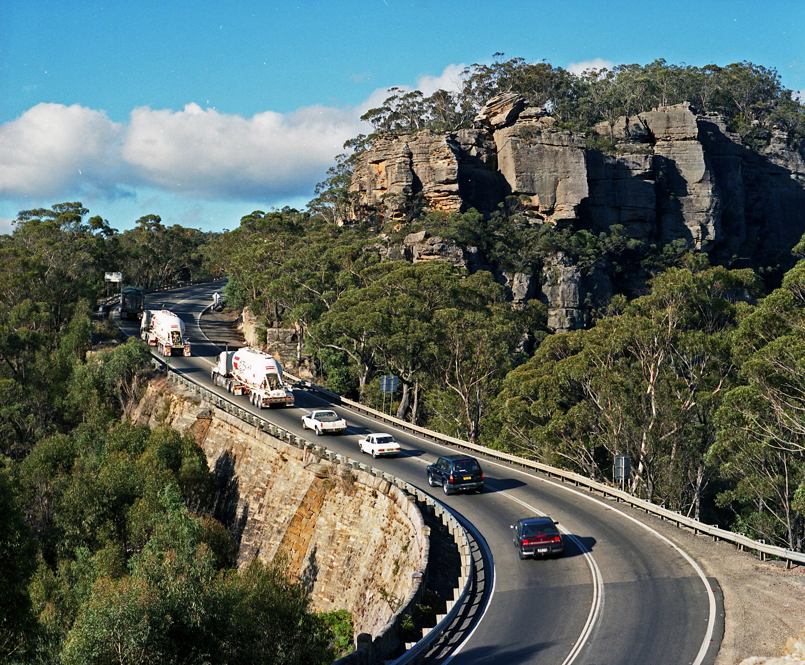
Victoria Pass solved an urgent and practical problem. The old descent down Mount York with its 1:4 gradient had been a hazard that claimed livestock, damaged vehicles, and deterred settlers. The new pass at a gradient of 1:15 made the journey to Bathurst and the western interior immeasurably easier.
Mitchell’s road was the first significant improvement since Cox’s track of 1815, and its social and economic consequences were profound. The Bathurst district, and by extension the vast western plains beyond, depended on this single corridor for the movement of produce, livestock, timber and supplies to and from Sydney’s ports. The pass would later carry the frantic traffic of the 1850s Bathurst gold rush, when thousands of fortune-seekers poured westward over the mountains.
Travellers were lavish in their praise. Charles Darwin, visiting the colony in 1836, described the road as “worthy of any line of road in England”. Artists and photographers were drawn repeatedly to the dramatic conjunction of stone, gorge and sky, and their sketches, paintings and later photographs became important historical records. The site, wrote historian Grace Karskens in her seminal 1988 study, “was intended to convey a sense of progress and civilisation, for it was evidence of the colony’s growing resources and sophistication”.
The pass also holds darker resonances. It was built by men in chains, living in a stockade at the foot of the pass. The Mt Victoria stockade housed hundreds of convicts throughout the construction period and was broken up in 1833 once the pass was made trafficable, before being re-established later for repair work. The causeway is, as Karskens wrote, “a museum of convict work and achievements, and still graphically illustrates the difficult, dangerous and laborious nature of their work on early roads”.
The Ghost of the Pass
The pass accumulated its own folklore. In the 1800s, travellers at night reported a supernatural encounter at Mitchell’s viaduct, the “second bridge” on the eastern side of Victoria Pass. Horses grew restless and a figure dressed entirely in black was said to appear suddenly before travellers, arms raised, eyes shining in the darkness.
History gives this ghost a name: Caroline Collits, née James, a young woman murdered on the road to Hartley in the early 1840s. She had married into the family of the proprietors of the inn at Hartley Vale but was killed, her skull crushed with a stone, beside the road on Victoria Pass at around seventeen years of age. The man accused of her murder was acquitted, and the case remained unsolved. The tale became part of the living folklore of the pass, a reminder that the road exacted its human costs long after the convicts laid down their tools.
The Railway Age and Road Decline
The extension of the railway over the Blue Mountains in the 1860s, reaching Mount Victoria in 1868, shifted the calculus of travel dramatically. The mountain roads were used less frequently, and many sections fell into disrepair. Victoria Pass entered a quiet period, carrying local traffic and the occasional determined drover, but no longer the principal artery of colonial commerce.
For a period in the 1840s, maintenance of the pass had been carried out by convicts under Captain J. E. Bull, stationed at a stockade at Blackheath. After transportation of convicts to New South Wales ended in 1840, the workforce changed but the maintenance imperative did not.
The Motorcar and Berghofer’s Pass
The arrival of the motor car in Australia after 1905 brought roads back into prominence and created a new problem at Victoria Pass. Early automobiles simply lacked the power to climb the original 1832 gradient. A local councillor, J. W. Berghofer, the first president of Blaxland Shire, lobbied for the construction of a gentler alternative.
Berghofer himself was a fascinating figure: born Johannes Wilhelm Berghöfer in 1840 in the German state of Kurhessen, he had emigrated to Australia to escape religious and political persecution and eventually settled in Hartley in the 1870s, where he ran the former Queen Victoria Inn and general store. The pass that bears his name was his lasting civic legacy, though the tribute was double-edged. During the First World War, with anti-German sentiment running high across Australia, Berghofer’s name was erased from the inscription on the pass.
Work on Berghofer’s Pass began in 1907 and the route opened in 1912. It curved sharply along the mountain’s edge below and to the north of the old causeway, featuring rubble retaining walls, stone and pipe culverts and substantial cuttings. Its gentler grades suited the early motor cars, but its tight curves were a nuisance.
By 1920, motorcars had become powerful enough to negotiate the old causeway again, and both roads were used concurrently. Berghofer’s Pass was officially closed in 1934, though it continued to be used unofficially, including by at least one charcoal-burning truck hauling bales of hay in the years after World War II, when its more modest gradient was still valued.
In 1979, Berghofer’s Pass was incorporated into a network of signposted walking tracks along historic early mountain crossings. Today it remains a delightful 4.5-kilometre return walk from Mount Victoria, offering travellers glimpses of the old roadway, retaining walls and the dramatic views that once greeted early motorists.
The two roads, Mitchell’s 1832 line and Berghofer’s 1912 deviation, still exist side by side on the hillside, a physical palimpsest of road-building across two centuries.
The 20th Century: Widening and Bitumen
In 1933–34, the then Department of Main Roads widened Victoria Pass and reconstructed the gravel pavement. The deep loop at the base of the pass, still in use today, was constructed at this time to replace the somewhat irregular lower alignment of Berghofer’s Pass. The road was later sealed with bitumen as traffic volumes grew.
By the mid-20th century, Mitchell’s original stone embankments were increasingly hidden beneath Armco safety fencing and road furniture, their presence intuited by travellers more than seen. Yet the stone walls remained the fundamental structural elements of the road, no upgrading to the core masonry had occurred since Mitchell’s original construction.
Recognition and Heritage Listing
Victoria Pass has attracted formal heritage recognition from multiple bodies. The National Trust of Australia (NSW) classified the pass and included it in the Hartley Valley Landscape Conservation Area. The Victoria Pass stone causeway was recognised as an item of environmental heritage significance in the Greater Lithgow Local Environmental Plan 1993, protecting it under the Heritage Act of NSW. In 2007, Mitchell’s Causeway was listed on the NSW Heritage Register , the only known substantial stone causeway structure from the early colonial period in NSW.
In 2002, the Institution of Engineers Australia and the Roads and Traffic Authority NSW dedicated the pass as a National Engineering Landmark, placing it in the company of the Great North Road and the Lithgow Zig Zag. In 2001, the Road Carriers Association cited it among Australia’s most significant road engineering achievements. The National Trust awarded conservation work on the causeway its Conservation Landscape prize at the 2017 National Trust Heritage Awards for NSW Roads.
The significance of the site has also been recognised for its role in documenting convict management and the expansion of the colonial frontier westward, processes that were, in Karskens’ words, “current throughout the colony and made the expansion of that colony possible”.
Crisis in 2026: The Causeway Fails
In early March 2026, Transport for NSW’s proactive monitoring systems detected something alarming: significant cracking and structural movement in the road surface of Mitchell’s Causeway. On 8 March 2026, the Great Western Highway was closed in both directions at Victoria Pass, the first full closure in the causeway’s nearly 194-year operational life.
Geotechnical investigations confirmed a “major geotechnical failure”. The fill beneath the road had deteriorated significantly, leaving voids and gaps in the causeway’s internal structure. NSW Roads Minister Jenny Aitchison described the situation as “incredibly serious,” noting that the closure would last at a minimum three months and that the government was “dealing with a major geotechnical failure on a fragile and historic section of road”.
The closure severed one of the two essential road routes across the Blue Mountains, forcing approximately 12,000 daily vehicles, including heavy freight trucks, onto a lengthy detour via Lithgow’s main street and Darling Causeway. The economic and logistical impacts on Blue Mountains and Central West communities were severe, with local businesses reporting sharp downturns and freight supply chains disrupted across the state.
The NSW Government committed $50 million to strengthen detour routes including Darling Causeway, Chifley Road and Lithgow’s main streets. Specialist engineers and geotechnical experts, including international consultants, were engaged to assess the damage and design a solution. By May 2026, Transport for NSW had received ten proposals from engineering firms competing to repair or replace the 1830s causeway, with a final solution expected within weeks.
The causeway’s heritage-listed status means any intervention must balance the preservation of significant colonial fabric with the engineering imperative to restore the road to a safe, functional standard, a tension that has defined its management for decades.
What Victoria Pass Means
Victoria Pass is more than a road. It is a compressed archive of colonial history, the ambition of a Scottish surveyor who defied his governor, the labour of hundreds of men in chains, the spectacle that moved Charles Darwin to admiration and Conrad Martens to his sketchbook. It is the hinge point between Sydney and the western interior, the gateway through which gold rushers poured, along which farmers moved their produce and travellers wrote their journals.
It carries within its ashlar masonry the memory of the convict experience: the “difficult, dangerous and isolated” work of men who built with their hands something that has outlasted every expectation of its builders. And it carries, too, the ghost of Caroline Collits, a reminder that the road through the mountains was not always a path to fortune or freedom.
In its current crisis, Victoria Pass faces perhaps the most significant test of its nearly two centuries of continuous use. The engineering problem is formidable: a structure built for horse-drawn wagons, now carrying modern semi-trailers, has reached a point of internal failure that the original builders could not have foreseen. The challenge for contemporary engineers and heritage authorities is to find a solution that preserves what is genuinely irreplaceable while meeting the transport demands of a region that depends on this road — as it always has, for its economic life.
The stone walls of Mitchell’s Bridge have stood for nearly two hundred years. The question now is what comes next.
This article draws on the 2001 National Engineering Landmark nomination document by Glenn Rigden, the foundational 1988 historical and archaeological study by Grace Karskens, the National Trust of Australia, the NSW Heritage Register, and contemporary reporting from 2026.
Frequently Asked Questions (FAQ):
Victoria Pass, Mount Victoria
What is Victoria Pass in the Blue Mountains?
Victoria Pass is a historic colonial road located on the Great Western Highway at Mount Victoria in the Blue Mountains, NSW. Constructed between 1830 and 1838 using convict labour, it was designed by Surveyor General Major Thomas Mitchell to provide a manageable descent from the Blue Mountains ridge down to the western plains. Its centrepiece, Mitchell’s Bridge (also known as the Causeway), is a spectacular hand-built stone structure that remains in use today as part of one of Australia’s major highways.
Who built Victoria Pass?
Victoria Pass was built by convict chain gangs working under three successive Assistant Surveyors: P. Elliot (1830), John Lambie (1831) and John Nicholson (1832). At its peak, nearly 400 convicts were working on the pass, with 216 of them in irons, guarded by soldiers from the 4th and 17th regiments. The project was instigated and championed by Major Thomas Mitchell, the Surveyor General of New South Wales from 1828 to 1855.
When was Victoria Pass built and opened?
Construction began in September 1830 and the pass was officially opened on 23 October 1832, when Governor Sir Richard Bourke led a ceremonial procession down the new road. However, work on the fine ashlar masonry walls and parapets continued until approximately 1838, making it an eight-year construction project in total.
Why was Victoria Pass built?
Victoria Pass was built to replace the dangerous and near-vertical descent down Mount York on William Cox’s original 1815 road to Bathurst. The old route had a 1:4 gradient, making it treacherous for heavy vehicles and livestock. Victoria Pass offered a far gentler 1:15 gradient, making travel to the western interior of NSW significantly safer and more practical for settlers, farmers and traders.
What is Mitchell’s Bridge at Victoria Pass?
Mitchell’s Bridge, also called the Causeway, is the centrepiece engineering structure of Victoria Pass. It is an elevated stone embankment halfway down the descent, where the road spans a narrow rocky chasm. Built from fine Type 3b ashlar sandstone masonry, the walls extend 107 metres on the north side and 67 metres on the south side, ranging from 2.5 to 10 metres in height. It is listed on the NSW Heritage Register and is recognised as one of the finest examples of early colonial road engineering in Australia.
Is Victoria Pass heritage listed?
Yes. Victoria Pass and Mitchell’s Causeway are protected under multiple heritage designations. Mitchell’s Causeway was listed on the NSW Heritage Register in 2007. The pass is also classified by the National Trust of Australia (NSW), included in the Hartley Valley Landscape Conservation Area, and recognised as a National Engineering Landmark by the Institution of Engineers Australia (2002). It is protected under the Heritage Act of NSW.
What happened to Victoria Pass in 2026?
On 8 March 2026, the Great Western Highway was closed in both directions at Victoria Pass after Transport for NSW detected significant cracking and structural movement in Mitchell’s Causeway. Geotechnical investigations confirmed a major failure in the fill beneath the road, leaving dangerous voids within the structure. It was the first full closure in the causeway’s nearly 194-year history. The NSW Government committed $50 million to manage detour routes, and by May 2026, ten engineering proposals had been submitted to repair or replace the causeway.
What is the ghost story of Victoria Pass?
Victoria Pass has a well-known ghost story connected to a young woman named Caroline Collits, who was murdered near the pass in the early 1840s. Her skull was crushed with a stone beside the road and the man accused of her murder was acquitted, leaving the case unsolved. In the 1800s, travellers on the road at night reported seeing a figure dressed entirely in black appearing suddenly near Mitchell’s viaduct, with horses growing restless and refusing to pass. The story of Caroline Collits became part of the enduring folklore of the Blue Mountains.
What is Berghofer’s Pass and how does it relate to Victoria Pass?
Berghofer’s Pass is an alternative road deviation built between 1907 and 1912 below and to the north of Victoria Pass. It was constructed because early motor cars lacked the power to climb the original 1832 gradient. Local councillor J. W. Berghofer, the first president of Blaxland Shire, lobbied for its construction. By 1920, more powerful cars could manage Victoria Pass again, and Berghofer’s Pass was officially closed in 1934. Today it is a popular 4.5-kilometre return walking track from Mount Victoria, and the two roads sit side by side as a visible record of two different eras of road building.
Can you walk to Mitchell’s Bridge at Victoria Pass?
Access to Mitchell’s Bridge and the causeway walls on foot is difficult and restricted due to the active highway. The structures are partly visible from the Mitchell’s Ridge Lookout. Berghofer’s Pass (currently closed), the adjacent historic walking track, offers the best opportunity to view the surrounding landscape and remnant historic road infrastructure on foot from Mount Victoria.
How significant is Victoria Pass in Australian engineering history?
Victoria Pass is considered one of Australia’s most significant examples of early colonial road engineering. It was declared a National Engineering Landmark in 2002, placing it alongside the Great North Road and the Lithgow Zig Zag. The fact that a hand-built stone structure from the 1830s continues to carry modern semi-trailer traffic nearly 200 years after construction is regarded as a remarkable testament to the skill of the convict labour force and the engineers who directed them. Historian Grace Karskens described the causeway as “a museum of convict work and achievements.”
What Aboriginal heritage is associated with Victoria Pass?
The Blue Mountains, including the area around Mount Victoria and Victoria Pass, are part of the traditional Country of the Dharug and Gundungurra peoples. The mountains sit at the intersection of six Aboriginal nations including the Darkinjung, Dharawal, Wiradjuri and Wonnarua. Aboriginal pathways and knowledge of the landscape predate European settlement by tens of thousands of years and were significant in guiding the first European crossing of the Blue Mountains in 1813.